Monday, December 17, 2012

Fort Madison, Part I

This is a bit of a teaser, but archaeologist Mechelle Kerns promises more details as her schedule allows. Dr. Kerns is presently a professor of History at the United States Naval Academy (USNA) and also serves as an Assistant Curator at the USNA Museum. She has furnished the preliminary details of her recent discovery of an early 19th century fortification near Annapolis. Read on...

As has been mentioned in earlier posts, at the outset of the War of 1812, the British started cruising around in the Chesapeake attacking settlements, burning farms, and generally wreaking all kinds of havoc. This tension with Britain naturally led American citizens to take measures to protect their port towns, and Annapolis, Maryland's capital, was no exception. Even before the conflict with the British started, forts were constructed near strategically important cities along the eastern seaboard. Fort Severn was constructed around 1808, where the United States Naval Academy now stands, and Fort Madison, slightly larger, was built across the river at the same time. 
This 1819 map, provided by USNA professor Mechelle Kerns, shows the locations of Forts Severn and Madison.
In preparation to defend the capital of Maryland, Forts Severn and Madison were made ready for war in the late summer of 1813. Men, materials, and artillery were moved to the forts and both were garrisoned from 1813 until 1815. Fortunately, in the War of 1812, as in the Revolution, the British did not attack Annapolis.


An article in the Maryland Gazette in 1813 discusses the pleasing state of military preparedness at Fort Severn. 

In 1845 the Army transferred Fort Severn to the Navy for use as a training school for officers. The fate of Fort Madison was unknown, until very recently. 

Archaeologist and USNA professor Mechelle Kerns became interested in the fate of Fort Madison as the 200th anniversary of the War of 1812 approached. One day, in a discussion with USNA Museum Senior Curator Jim Cheevers, the topic of Fort Madison came up and Kerns' curiosity was piqued. A search through the Navy's land records led her to the discovery of a plot of land called the "Fort Lot." Her research eventually led her to the Naval Academy rifle range on Greenberry Point, across the Severn River from Annapolis...

More to come!

Saturday, December 1, 2012

In Search of the Elusive British Encampment at Benedict


By Julie M. Schablitsky

On August 19, 1814 General Robert Ross landed 4,370 men on the shore of Benedict. The troops camped on the hills and slopes above Benedict in the event of a western overland attack from the Americans and to have an unobstructed view of the port. During their first night on land, they rested and prepared for their march to Washington.  British Lt. George Robert Gleig (1821) reported:

            On the brow of the hill, and above the centre of the line, were placed the cannon, ready
            loaded, and having lighted fuses beside them; whilst the infantry bivouacked immediately
            under the ridge; that is, upon the slope of the hill which looked towards the shipping;

Benedict was only a temporary camp and in the morning the men pushed towards Washington. After defeating the Americans in the Battle of Bladensburg (See November 2, 2012 post) and burning the nation’s capital, the troops marched back to Benedict. On August 29th, they camped here once again and boarded their ships in the morning.

The Search…

Since last spring, Charles County and Maryland State Highway Administration archaeologists have been searching for evidence of a War of 1812 British encampment along MD 231. Although the archaeological signature of a 200-year old campsite occupied for no more than two nights would be a challenge to find, we thought it was worth a try. Much like a swarm of locusts, we knew that 4,000 men could not pass through Benedict and not dropped something on the grassy hills. Military uniforms, especially ones from the 18th and 19th centuries, were adorned with dozens of buttons located on waistcoats, uniform coats, sleeves, and pant legs---they even had button fly.  Typical use on land or sea would cause the strings to wear---button loss was common. Perhaps the infantry needed to cast munitions in preparation for battle, so burned earth from a hearth and lead sprue may have survived the farmer’s plow and erosion.  Even dropped musket shot and coins could have fallen out of cartridge boxes and pockets only to be found by an archaeologist years later.

An example of a circa 1812 British Uniform
The first step in any historical archaeology project is to hit the archives and other 
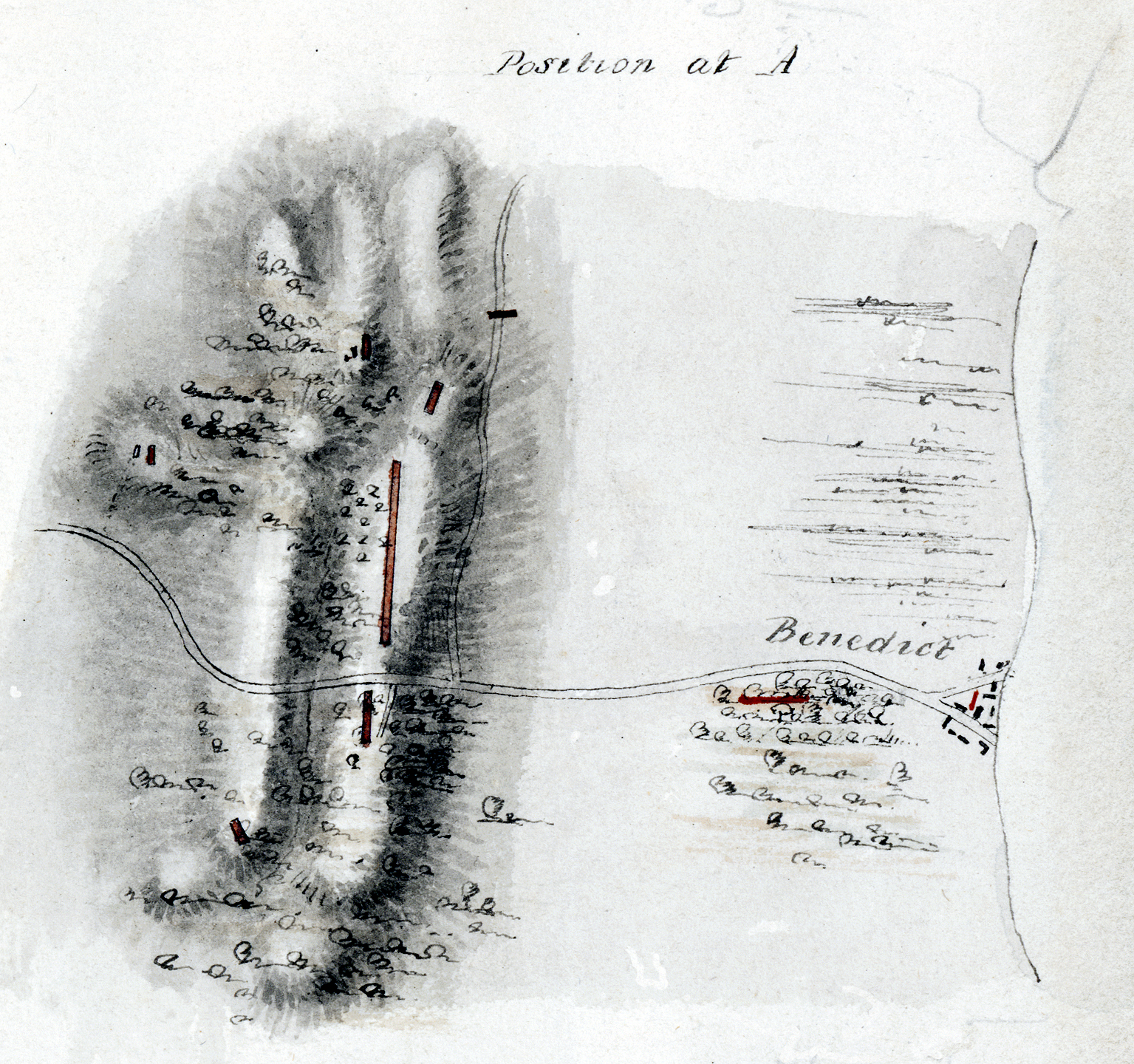
scholarly repositories to seek out old maps and primary documents. These written accounts and images direct our research. Luckily for us, a nice colored map exists of the Benedict camp and it shows the exact locations of the British pickets on the landscape. As suggested by the map, as well as Gleig’s report, the men camped on top of the hills and the slopes above Benedict as they prepared for an intense overland march. The road depicted on this map travels west out of Benedict.  This eastern road trace out of Benedict is gone, but the current alignment of MD 231 is sitting right on top of the old colonial road just east of the hills.

Today, MD 231 is a paved, busy highway lined with utility poles.  The top of the hills, where the British had camped, is now crowned with homes and outbuildings.  In order to make a nice flat surface to build in the 20th century, the hills were graded and steep driveways cut into their sides. Some of the residents even added a below ground swimming pool and underground garage. All of these modifications likely erased any evidence of a British encampment here; however, the slopes below the hills were only plowed and some areas may contain intact archaeological deposits. Metal detecting over the years by relic collectors may also have removed a significant number of artifacts associated with the encampment. But, there was only one way to find out if anything still survived into the 21st century.


Admittedly, the archaeological signature of the War of 1812 camp occupied for less than 48 hours would be subtle at best and excavating small holes across the area to look for a sparse collection of military artifacts would be leaving too much to chance.  Since almost everything lost or discarded by the British would be metal, the best way to find where “X” marked the spot was through a systematic metal detector survey. We were well aware that relic collectors had been there before us, especially in the fields below the hills where the African American Civil War camp once stood.  But, there was a good chance that metal artifacts remained undetected and preserved in the soils.  So last spring, we placed metal detectors in the arms of archaeologists and we surveyed along the highway right of way and hills in search of brass and lead. 

After a few weeks of metal detecting and digging small holes that revealed mostly aluminum cans and random iron, we finally unearthed a small number of .69 caliber musket balls on the north side of MD 231.  This size of shot could have only belonged to a British musket. 


In addition to shot, we also discovered three plain, brass buttons that date to late 18th to early 19th century.  These undecorated buttons cannot be unequivocally connected with the War of 1812 encampment, however, their proximity to the shot and historic context of a 200 year old camp site, makes it probable that at least some of these buttons fell from a British uniform.  


Does this mean we found the camp? Well, not exactly.  We needed to find something more than a handful of buttons and bullets to say we located the British camp site—all we can really say is that the British passed through here.  So, what would be our smoking gun?  Of course, buried remnants of an old campfire sprinkled with lead and War of 1812 British buttons and other military artifacts---something with size and diversity.  With a landscape that has been eroding for 200 years, a few decades of active metal detecting, and a site occupied for less than 48 hours, we had our work cut out for us. And being scientists, we really needed something more to convince us.
  
October 2012

The paucity of War of 1812 artifacts we found last spring pushed us to look harder, try new methods, and dig deeper to understand what was happening with the soil and why this camp was so hard to find.  We felt that the north side of MD 231 was searched pretty thoroughly, so we concentrated our efforts on the south side of the highway----after all, the camp did straddle the road. The first thing we did was put away our metal detectors and instead, pulled out an even bigger (and much more expensive) piece of technology from our tool kit: the magnetometer.


The magnetometer was taken out to search the area for remnants of old fire hearths and pits. After a few days of survey, a map was produced that showed over a dozen anomalies, or curious buried features, that could be natural or cultural.  The archaeologists excavated small holes into each one of them---all came back negative for cultural material except for one. 

In a gently sloping area we found a very well preserved fire hearth that appeared to have repetitively used for quite some time.  The soil was heated to such a high temperature for such a long time that the ground became rock hard and turned red.  A large test unit was used to further investigate the fire hearth.  Could this be a British camp fire?  Or was this fire hearth associated with the nearby African American Civil War site, Camp Stanton? We found very few artifacts, but the ones we did uncover included cut nails, calcined bone, and a few broken ceramic sherds from tea wares that dated the fire to the mid-19th century. 


Unfortunately, we never found the exact location of the British War of 1812 encampment in Benedict, but we did learn a few things.  First, the landscape above and just below the hills we searched is eroded and unlikely to contain any intact archaeological deposits dating before the Civil War. Although it is possible to find a few early artifacts, those items were likely re-deposited during rain storms and construction events during the later 19th and 20th centuries. Although much of the area just below the hills has also been eroded and somewhat impacted through plowing and heavy metal detecting, parts of Camp Stanton still survive---and those parts can tell future archaeologists the size of the camp and how the African American soldiers and their officers lived and trained during the winter of 1863-1864. Our search for the War of 1812 has concluded in Benedict, but our quest for how African American Civil War soldiers lived and trained in this part of Charles County has just begun! 

Friday, November 9, 2012

Caulk's Field


Today we'll find out about Caulk's Field, an Eastern Shore Battlefield that has miraculously survived the centuries more or less intact - meaning it can still provide information about the war as it was fought on the Eastern Shore of the Chesapeake Bay. SHA Chief Archaeologist Julie Schablitsky provides the details...

Caulk’s Field: Maryland’s Best Preserved War of 1812 Battlefield

To commemorate the War of 1812 bicentennial, the Maryland Department of Business and Economic Development (DBED) secured a National Park Service, American Battlefield Protection Program (ABPP) grant to conduct an archaeology survey across Caulk’s Battlefield.  The battle was an American win and the site remains relatively unaltered. DBED chose the Maryland State Highway Administration (SHA) and University of Maryland (UM) to carry out the archaeology survey and mapping project to determine troop and artillery locations, areas of intense fighting, and battlefield boundaries. 

During the month of August 1814, the citizens of Kent County observed a British ship and associated barges in the Chesapeake Bay. Captain Peter Parker anchored his frigate, HMS Menelaus, just off of Poole’s Island in an attempt to keep the eastern shore militia from coming to the aid of the Americans in western Maryland. Parker and his men came ashore several times to take supplies from the local farms and to burn private property to keep it from being used by American troops. 

Drawing of HMS Menelaus and Eclair by Lt. William Innes Pocock.
On the night of August 30, 1814, the British burned and looted Richard Frisby’s farm and took four enslaved African American men as captives.  When Captain Parker interrogated the slaves that night, he learned the location of American Lieutenant Colonel Philip Reed’s camp. The British landed around 11:00 that evening to search out and destroy the American camp, take prisoners, and extract information from the troops regarding the protection of Baltimore.  

View of British taking livestock, supplies, and slaves (Courtesy the Patuxent River Naval Air Station)
At 11:30pm that same night, Reed received word from his picket that the British landed near Waltham’s farm. Believing their intent was to burn and pillage, Reed took his men and marched towards Waltham’s farm. Within minutes he learned the British were actually in pursuit of them! At this point, he countermarched, moved his camp into Caulk’s field and positioned the troops on “the rising ground about three hundred paces in the rear—the right towards Caulk’s house and the left retiring on the road, the artillery in the centre, supported by the infantry on the right and left.”  A fortified line took the center of the field, and an advance troop of Americans lay in wait for the British.

As soon as the British came into view, the Americans fired into them and then fell back to the fortified line with the artillery. The British attempted to take the American left flank, but were unsuccessful. They continued to push the front American line and forced Reed to fall back. After almost an hour of fighting, Reed’s men were running low on ammunition, but they held their position. Casualties escalated rapidly into the dozens, and Captain Peter Parker was killed in the action. Finally, the British quit the field and returned to the Menelaus.

Colored map of the battle at Caulk’s field drawn by Acting Commander Henry Crease while aboard the HMS Menelaus. Reed’s account places his left flank on the road, not the artillery as shown here.
The Archaeology

In the spring and fall of 2012, the SHA and UM archaeologists, along with volunteers from BRAVO, conducted a metal detector survey across 40 acres of the battlefield.  The archaeologists searched for lead and ferrous munitions (musket balls, buck shot, rifle shot, and canister shot), brass clothing buttons, and other battle-related artifacts. Where each artifact was found, an archaeologist mapped the location with a total station to record its exact position.

View towards northeast of battlefield and archaeologists setting up total station to record the exact location of artifacts. 
After the artifacts were mapped, they were collected and taken back to the SHA laboratory for processing and cataloging.  The musket balls were studied closely, measured, and weighed. Lead shot was separated into three main categories: buckshot (.25-.36 cal.), rifle/pistol shot (.37-.58 cal.) and musket shot (.59-.75 cal.). British and American lead musket shot can be distinguished from each other by measuring the diameter of the ball. The standard issued British gun during the War of 1812 was the Brown Bess musket. It had a 0.75-inch bore and was loaded with 0.69-0.70-caliber lead shot. The Americans held guns with smaller bores and therefore, their musket shot measures approximately 0.62 inches in diameter. 

Archaeologists recovered 35 pieces of shot from Caulk’s Field : 

8 British musket shot - 6 dropped and 2 fired
11 American musket shot - 7 dropped and 4 fired 
7 unidentified fired musket shot
3 rifle shot 
4 buck shot 
2 heavily impacted unidentified shot 

All of the shot pictured above was fired out of a musket aimed at a soldier. All of the above appear to have missed their mark. 

Most of the recovered musket shot was unfired, suggesting the lead balls were likely dropped during loading of a gun or perhaps spilled out of a cartridge box.

In addition to musket shot, archaeologists collected military buttons, canister shot, and other pieces of brass and iron. Based on the patterns of the artifacts, it is now possible to see where the different troops stood and fought on the landscape.  For example, a concentration of dropped American musket shot show where the Kent County men stood as they fired towards the oncoming British, while dropped British musket shot shows how far up field they pursued the Americans. This week archaeologists are surveying an additional 40 acres of agricultural field along MD 21 in an attempt to find how far back the Americans fell from their initial position. By the end of the project, we will have reconstructed the entire battle.

NOTICE: The battlefield is privately owned and trespassing is prohibited. Metal detecting was only performed under the guidance of professional archaeologists. 

Friday, November 2, 2012

Bladensburg Battlefield


In this post, we’ll find out about the archaeology of an episode that historian Daniel Walker Howe called "the greatest disgrace ever dealt to American arms” and "the most humiliating episode in American history": The Battle of Bladensburg. I know, I’ve really set it up to sound glorious, right? Actually, there really were Americans who comported themselves with an appropriate degree of military ardour that day (Commodore Joshua Barney, looking at you), but they were outranked by ineffective and pusillanimous officials who made a complete hash of things. 

On the morning of August 24th, 1814, General William H. Winder hastily positioned his American militia units in the fields above Bladensburg, Maryland. Until 1813, Winder had been a lawyer in Baltimore. Then he had a midlife crisis or something and became an Army officer. If you read about the Battle of Bladensburg in greater detail, you might get the sense that Winder was, perhaps, promoted beyond his capacity. Wikipedia tactfully suggests that he “failed to show effective command” in the Battle of Bladensburg, which is really putting it lightly. 

The British forces were led by Major General Robert Ross, a British Army officer who started his military career in 1789 and served with the Duke of Wellington in the Peninsular War. You’re probably thinking that this is a significantly more impressive resume than that of poor General Winder. Yeah. You’re totally right.

Robert Ross!
British troops entered the town of Bladensburg around noon. Colonel William Thornton's 85th Regiment of Foot began an assault across the small bridge spanning the Eastern Branch – now known as the Anacostia River. The first units suffered some pretty gory casualties, but the British Empire wasn’t built by people who wilted just because of a little musket fire. The British managed to push across the bridge and establish strategic positions in the thickets along the riverbanks.


A sketch map of the battle
Commodore Joshua Barney (more on him in later posts) had scuttled his Chesapeake Flotilla  - including his flagship the USS Scorpion - in the Patuxent River two days earlier. He arrived at the battlefield with about 400 sailors and a contingent of 120 marines under Captain Samuel Miller. 

They rolled two large 18-pounder cannon into the middle of the Bladensburg Turnpike, along with three 12-pounders on the right flank right on the border of Maryland and DC. The sailors were armed only with cutlasses and boarding pikes, while the marines carried muskets. Just to be clear: these guys had been fighting the British in the Chesapeake Bay and along the Patuxent River for months, blew up their ships and barges, and then they marched to the Navy Yard in DC, grabbed some cannons, and dragged them all the way to Bladensburg where they kept right on fighting the British. So…major props to Barney and the flotilla guys.
The British paused briefly as this apparently unimpressive band of reinforcements assumed their defensive position, but soon resumed their attack. In turn, Barney's men fired their 18-pounders "with the most destructive effect, sweeping the road and staggering the column." The British mounted several assaults directly into the line of cannon until they were forced to seek cover along Dueling Creek. Despite being pummeled by cannon fire, the British maintained heavy musket fire into the artillery positions, eventually shooting Barney's horse out from under him.  


 The British followed the deep channel of Dueling Creek around to Barney's right, and from this position drove off the militia units defending the hilltop. By this time, General Winder had ordered a retreat, leaving the "flotilla men" to fend off the British – which, you guys, they totally did. Barney suffered a serious wound from a musket ball to his upper right thigh.

Outflanked and out of ammunition, Barney ordered his sailors and marines to spike their guns and retreat.  Some sailors remained at their stations, and it was reported that they were bayoneted at their guns with fuses smoldering in their hands.  Washington fell to the victorious British that night.

Other battlefields, especially those from the Civil War, have been lovingly preserved, studied, and interpreted for the public. Bladensburg Battlefield, however, has been largely forgotten. The area where this battle was fought now contains suburban residences, a cemetery, parkland, and commercial developments. If you were to drive down Bladensburg Road today, trying to replicate the path the British took on their way to Washington, you would probably conclude that nothing of the original landscape survives. But archaeologists have discovered that in several places around the town, little pockets of this intact battlefield still survive. 
Looking for the Battle of Bladensburg at Fort Lincoln Cemetery
Using metal detectors, archaeologists have found several artifacts from the time of the battle, and are working with the National Park Service to create a plan for the management and interpretation of the Battlefield.
Musket balls from the Battle of Bladensburg

The last time someone saw this piece of lead shot, it was flying toward someone's vital organs in 1814.
You can find out all about the archaeology at Bladensburg Battlefield, and other archaeological projects in Bladensburg, at SHA's interactive website. You can even watch this video about the battle! Have fun, and check back soon for more 1812 archaeology!

Monday, October 22, 2012

Welcome


Join us and explore War of 1812 Archaeology!

The Maryland State Highway Administration's archaeologists are joining in the state's commemoration of the bicentennial of the War of 1812, and we want to share our latest finds with you - so follow us here as we excavate War of 1812 battlefields, encampments, and even a shipwreck! In addition to sharing details of the sites we've found along Maryland's highways, we'll be featuring guest posts by archaeologists who are doing their own work on 1812-related sites, in Maryland and anywhere else such sites might be found. 

We hope you’ll stop by often to read about our efforts to uncover new and fascinating stories about this remarkable time in our nation’s history.

About the War of 1812

Look, it’s no secret that the War of 1812, sandwiched between the Revolutionary War and the Civil War, is basically the neglected middle child of significant early American wars. But we have arrived at the 200th anniversary of the War of 1812, and it is time to start paying a little more attention to this obscure, but nonetheless significant, conflict. Here’s a short synopsis for those of you who are not completely conversant with the history:

In the early 19th century, the British and the French were fighting the Napoleonic Wars, and the Americans were getting hassled all the time. The United States, fresh from the Revolution, was neutral during the Napoleonic conflicts, but American ships were caught in blockades, had their goods confiscated by the British or French, or had their crews impressed into the Royal Navy. Very exasperating. On top of all that, the British were encouraging Indian groups in the west to attack frontier settlements, and supplying the Indians with weapons. They were probably a little worried about American threats to invade and annex parts of Canada. There was a lot going on, is what I’m saying. 

Sick of getting pushed around by the British, President James Madison signed a declaration of war against Great Britain on June 18, 1812. America wasn't really ready for a war. We didn't have much of a navy. So President Madison issued Letters of Marque and Reprisal to private ship owners. We might have been unprepared for war, but DANG were Marylanders ready to privateer the heck out of the British Navy. If you've ever heard of a Baltimore Clipper, this is probably why. The clipper ships enjoyed tremendous glory and usefulness as privateers during the conflict. A clipper called the Chasseur, commanded by Captain Thomas Boyle, was especially brash, impertinent, and therefore awesome. Go read the Wikipedia page if you have time. 


In 1814, feeling pretty good about themselves after sorting out Napoleon, the British initiated a three-part strategy for a war with the United States. First, they sought control of the Hudson River.  American incursions into Canada had initiated conflict along the northern border in 1812, and the British counter in this area had the potential for catastrophic consequences to the United States.  Second, the British launched an attack on the Chesapeake region and the Nation’s Capital as a political statement.  In part, this campaign was retribution for the burning of Fort York (Toronto) by American forces in 1812.  The British were also getting seriously annoyed about all those privateers from the Chesapeake, so another major focus was "that nest of pirates" in Baltimore. Finally, a western attack directed at New Orleans sought to control the Mississippi River, halt America’s westward expansion, and isolate the young democracy. 

In the past, the War of 1812 was considered a sidelight of American history…some even say the “forgotten war.”  Happily, as a result of the bicentennial commemoration of the War of 1812, the public is beginning to recognize the significance of the War in the evolution of the newly independent United States and its fledgling experiment in democratic rule.  Today many historians view the War of 1812 as a decisive crossroads that profoundly affected the nation’s development, a second war for independence. It wasn’t a blip, it wasn’t a hiccup, it was a seriously big deal and it is packed with fascinating stories. Like plucky underdogs? You’re going to LOVE the War of 1812. 


Here in Maryland, it is well-remembered - and for good reason. Maryland and the Chesapeake Bay were national centers of settlement, commerce, and government. The British Chesapeake Campaign was a reflection of the region’s strategic importance, and placed Maryland at the core of national events.  Maryland saw more military actions during the War of 1812 than any other state.  The War of 1812 tested the young democracy and its diverse population including slaves and freemen, forged a national identity, and created a new international political framework.  On a local level, Maryland’s contributions to the defense and heritage of the nation include the pivotal clash at Fort McHenry, which may have ensured the nation’s survival, and inspired our national anthem, The Star-Spangled Banner. 


The United States’ successful, solitary stand against the British Empire greatly enhanced the country’s international prestige and forced Great Britain to acknowledge the full economic and political sovereignty of their former colony. The war consolidated the emerging democracy and forged the nation into a unified whole with a new national outlook.  For the first time, citizens began to perceive themselves as a distinct, American people.

Archaeology of the War of 1812

We’ll have details and highlights of excavations all over Maryland and anywhere else the War of 1812 left traces behind -- so follow along and make new discoveries with us. 

Working on a War of 1812-related site? We want to hear from you! Contact us at SHACulturalResources@gmail.com or in the comments section. 

10/22/2013 by Lisa Kraus